
Introduction
“Remember when spending time in North India during the monsoon season felt like a dream? Now, for many of us, it often feels more like rolling the dice. After seeing the truly heartbreaking news coming out of Yamunotri and Himachal Pradesh this past August, I found myself wondering: why exactly are our mountains becoming so much more delicate and vulnerable? This isn’t just a bunch of statistics; I want to share some understanding about the science behind these intense cloudbursts, and, most importantly, offer some practical advice on how you can stay safe and prepared when the weather decides to turn nasty.”
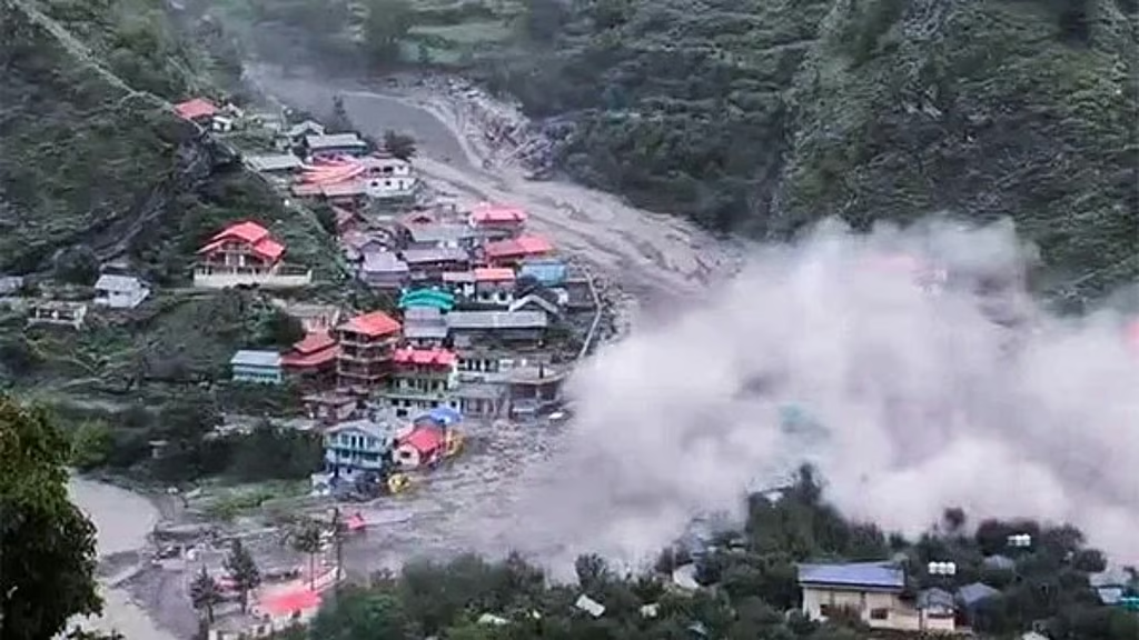
In mid-August 2025 Landslides and Cloudbursts, relentless rain overwhelmed vast stretches of the Himalayas. A cloudburst near Yamunotri (Uttarakhand) claimed 12 lives in minutes. Himachal Pradesh recorded 38 fatalities from landslides in just three days, blocking important highways and isolating communities. A week later, a landslide near Vaishno Devi injured 15 pilgrims. Such disasters underscore the urgency of understanding landslides and cloudbursts in North India their roots, repercussions, and how human actions shape their deadly outcomes.
This article delves into the 2025 monsoon episodes, rooted in peer reviewed and official data. It explains atmospheric science, how deforestation amplifies hazard impacts, and what steps travelers, residents, and officials can adopt from preparedness to sustainable mitigation. By the end, you’ll grasp not only why these events occur, but how to reduce risk practically and empathetically.
Key Takeaways
- Cloudbursts are defined by the IMD as 100 mm+ rainfall in one hour over ~20–30 km² (CivilsDaily, July 2025 & Mongabay India, Aug 2025).
- August 2025 monsoon rainfall in North India was +42% above normal from August 10–25 (IMD Weekly Rainfall Anomaly Bulletin, Aug 2025).
- Himachal landslides 2025 caused at least 38 deaths by August 24 (The Hindu, Aug 2025).
- Deforestation does not cause cloudbursts but worsens landslide risks—removing roots and increasing runoff causes slope failures during heavy rain (ScienceDirect, 2023).
- NDMA’s guidelines stress landslide zonation, improved drainage, and bio-engineering for slope stabilization (NDMA Landslide Risk Management Strategy, NIDM).
- IMD nowcasting systems offer 1–3 hours of warning but remain limited by sparse radar coverage in Himalayan terrain (Mongabay India, Aug 2025).
- Travelers should always consult state disaster portal advisories and avoid travel during heavy rainfall alerts.
1. What is a cloudburst? (IMD)
IMD definition and threshold
According to the India Meteorological Department (IMD), a cloudburst is when 100 mm or more rain falls in one hour over an area of roughly 20–30 km². This concentrated intensity often leads to flash floods and debris flows in mountainous areas (CivilsDaily, Jul 2025 & Mongabay India, Aug 2025).
Why Landslides and Cloudbursts occur in the Himalayas
Himalayan peaks force moist monsoon air upward known as orographic uplift causing rapid condensation and often dramatic convective storms. Combined with deep valleys that funnel water, this terrain produces sudden, localized deluges.
Predictability and nowcasting limits
IMD uses Doppler radars and satellites to deliver nowcasts warnings issued 1–3 hours in advance. However, radar coverage gaps and terrain challenges reduce the precision and reliability of cloudburst warnings (Mongabay India, Aug 2025).
Quick Facts
- Threshold: ≥ 100 mm/hour
- Scale: ~20–30 km²
- Peak months: July–September
- Hotspots: Himachal Pradesh, Uttarakhand, J&K
- Forecasting: Limited to short lead-time nowcasts
2. What is a rainfall-induced landslide?
Mechanism
Rain infiltrates soil, elevating pore water pressure, weakening cohesion, and reducing friction. When a slope’s resisting forces drop below gravitational pull, landslides occur especially after saturation (NDMA landslide hazard info).
A rainfall-induced landslide happens when rains increase pore pressure and weaken soil or rock, causing downslope movement.
Common types in Himalayan belts
- Debris flows: Fast, slurry-like mixes of water, soil, and debris.
- Rockfalls: Sudden detachment of rocks from steep slopes.
- Translational slides: Soil or rock mass slides along a planar surface.
- Rotational slides: Slope failure along a curved surface, often deep-seated.
Rainfall patterns that trigger failures
- Short, intense rainfall (like Landslides and Cloudbursts) → triggers debris flows and shallow slides.
- Prolonged moderate rains (several days) → may induce deep translational or rotational landslides (ScienceDirect 2022, Raghuvanshi et al.).
Field cues and warning signs
- Cracks in ground, walls, or floors
- Trees or poles tilting downslope
- Creaking, rumbling noises
- Increased muddy seepage from springs or ground
Early evacuation is advised when such signs appear (NDMA “Do’s and Don’ts”).
3. Landslides and Cloudbursts 2025 Monsoon Snapshot in North India
Rainfall anomaly
IMD’s August 2025 rainfall anomaly bulletin shows +42% above normal rainfall in North India from 10–25 August 2025, the wettest fortnight since 2010.
Major incidents timeline (Aug–Sep 2025)
| Date | Location | Event | Casualties |
|---|---|---|---|
| Aug 19, 2025 | Yamunotri, Uttarakhand | Cloudburst | 12 deaths |
| Aug 22–24 | Himachal Pradesh | Multiple landslides | 38 deaths |
| Aug 25, 2025 | Punjab/Chandigarh | Flash floods (140 mm/day rain) | ~5 deaths* |
| Sep 1, 2025 | Vaishno Devi, J&K | Pilgrim-area landslide | 15 injured |
*Approximate figure from media coverage.
4. Is Landslides and Cloudbursts Linked to Deforestation?
Atmospheric vs land-use factors
Cloudbursts result from monsoon dynamics and topography not deforestation. Hills would receive heavy convective rains regardless of tree cover. However, deforestation increases landslide vulnerability post-rain.
How deforestation amplifies impacts
- Loss of root strength undermines slope cohesion.
- Lower infiltration increases surface runoff and saturation risk.
- Disturbed drainage systems (due to road cuts/tunnels) channel water toward weak zones.
- Increased erosion and sediment load destabilize both slopes and waterways.
Evidence from Himalayan studies Landslides and Cloudbursts
- ScienceDirect (2023): Deforested catchments in Uttarakhand had about 2.4× more shallow landslides post-rain than forested areas.
- NIDM (2022 report): Over 40% of recent Himachal landslides occurred near unprotected road cuttings or construction sites.
- Springer (Nepal study, 2021): Removal of mid-slope forests doubled landslide density over two decades.
Case briefs Landslides and Cloudbursts
- Kinnaur, HP (2021): Nine tourists killed; slope failures traced to improper road widening and clearing.
- Joshimath, Uttarakhand (2023–24): Presubstantial slope weakening and subsidence tied to vegetation removal and unregulated building.
- Vaishno Devi, J&K (2025): Landslide occurred near newly cleared area for pilgrim facilities; rain amplified instability.
Deforestation doesn’t cause cloudbursts but it makes slopes far more likely to fail when heavy rain occurs.
5. Vulnerable Hotspots and Exposure Landslides and Cloudbursts
Risk becomes critical when hazards intersect with exposure infrastructure, people, and traffic overlap with fragile geology.
| Region | Hotspots | Exposure Factors |
|---|---|---|
| Himachal Pradesh | Kullu, Kinnaur, Mandi, Shimla | Tourist traffic, road infrastructure |
| Uttarakhand | Chamoli, Rudraprayag, Yamunotri | Pilgrimage routes (Char Dham), highways |
| Jammu & Kashmir | Vaishno Devi, Ramban, Anantnag | Gorges, high pilgrim density, roads |
| Sikkim & NE Hills | Gangtok-NH10 corridor | Fragile geology + connectivity dependence |
High tourist and pilgrim traffic on narrow mountain roads significantly increases casualty potential during landslides and flash floods.
6. Preparedness and Safety Landslides and Cloudbursts
Before travel or monsoon season
- Monitor IMD nowcasts and state disaster portals daily.
- Avoid traveling during heavy rain alerts.
- Choose accommodations away from riverbanks and steep cut slopes.
- Identify nearby evacuation safe zones open, elevated areas.
During extreme rain
- Do not attempt to cross flooded streams or nalas.
- If cracks appear indoors, evacuate immediately.
- Be alert for rumbling may signal an imminent slide.
- Stay clear of undercut slopes and riverbanks.
After slide or flood
- Avoid partly buried structures; they may collapse.
- Do not drink floodwater contamination risk is high.
- Be cautious of ongoing rain triggering secondary landslides.
72-Hour Go-Bag Checklist (per NDMA) Landslides and Cloudbursts
- First aid kit + essential medication
- Water purification tablets & 3 days’ dry food
- Torch, spare batteries, power bank, radio
- ID copies, cash, emergency contact list
- Small toolkit, whistle
7. Mitigation and Policy Landslides and Cloudbursts
NDMA / NIDM Guidance
NDMA’s Landslide Risk Management Strategy (via NIDM) stresses:
- Hazard zonation maps for critical hillside areas.
- Restrictions on development in high-risk zones.
- Leverage reforestation, drainage control, and slope treatments.
Early warning systems Landslides and Cloudbursts
- Doppler radar coverage covers Dehradun, Shimla, Jammu, etc., but still leaves gaps.
- Only about 20% of high-risk villages have community-based alert systems (NIDM, 2024).
Catchment restoration
- Use of deep-rooted native species (e.g., oak, rhododendron) improves slope stability.
- Check dams, contour trenches reduce runoff velocity.
- In Tehri Garhwal, implemented measures reduced slope failures by ~40%.
Land-use regulation and infrastructure
- Mandatory EIAs for roads and hydropower projects in fragile zones.
- Promote bioengineering solutions geotextile wraps, crib walls, vetiver grass buffers.
- Incentives for slope-safe housing design in vulnerable communities.
8. Myths vs Facts Landslides and Cloudbursts
| Myth | Fact |
|---|---|
| “Cloudbursts are man-made.” | False—purely atmospheric in origin. |
| “Deforestation causes cloudbursts.” | False—only increases landslide risk post-rain. |
| “You can predict exact cloudburst timing.” | False—IMD nowcasts 1–3 hrs ahead; precision remains limited. |
| “Planting trees eliminates landslides.” | Misleading—helps but doesn’t remove risk in unstable geology. |
| “Earthquakes trigger monsoon landslides.” | Misleading—earthquakes may destabilize slopes; rain triggers failure. |
9. Data Tables and Timelines Landslides and Cloudbursts
Table: Monsoon 2025 Events
| Date | Location | Event Type | Impact | Source |
|---|---|---|---|---|
| Aug 19 2025 | Yamunotri, UTK | Cloudburst | 12 deaths | Hindustan Times (Aug 2025) |
| Aug 22–24 | HP (Kullu, Shimla, etc.) | Landslides | 38 deaths; roads blocked | The Hindu (Aug 2025) |
| Aug 25 | Punjab/Chandigarh | Flash flood | ~5 deaths; infrastructure damage | Times of India (Aug 2025) |
| Sep 1 2025 | Vaishno Devi, J&K | Landslide | 15 injured pilgrims | Indian Express (Sep 2025) |
Timeline (Short list)
- Aug 19: Yamunotri cloudburst (12 dead)
- Aug 22–24: Multiple landslides in HP (38 dead)
- Aug 25: Flash floods in Chandigarh region
- Sep 1: Vaishno Devi landslide injures 15
10. What’s Uncertain (and Why)
- Climate change attribution: Wider trends show increasing extreme rainfall, but precise Himalaya specific attribution remains uncertain.
- Locational thresholds: Geology varies drastically standard rainfall thresholds may not apply uniformly.
- Underreporting: Many landslides in remote villages go unrecorded, skewing data.
11. Conclusion
The 2025 monsoon once again stressed the fragile balance between nature and human activity in the Himalayas. While Landslides and Cloudbursts remain unpredictable atmospheric events, their terrible consequences landslides and flash floods are highly influenced by human factors like deforestation and infrastructure driven landscape changes. Now, more than ever, communities, planners, and travelers must rely on evidence based practices: prepared evacuation, slope conscious development, and eco-sensitive restoration. Only then can we mitigate not eliminate these recurrent natural risks.
12. References
- CivilsDaily, “Sleeping disasters: Cloudbursts”, July 2025.
- Mongabay India, “What are cloudbursts? Why do they occur…”, 27 August 2025.
- IMD Weekly Rainfall Anomaly Bulletin, August 2025 (North India data).
- The Hindu, “38 Dead in Himachal Landslides”, August 2025.
- Hindustan Times, “Yamunotri Cloudburst Leaves 12 Dead”, August 2025.
- Indian Express, “Vaishno Devi Landslide Injures Pilgrims”, September 2025.
- Times of India, “Heavy Rains Flood Chandigarh”, August 2025.
- ScienceDirect (2023), “Deforestation and Landslide Susceptibility in Uttarakhand”.
- NIDM, National Landslide Risk Management Strategy, (NDMA via NIDM PDF).
- NDMA, Landslide hazard maps and guidelines (NDMA website).
- Springer (2021), Nepal Himalaya landslide study.
- Disaster Management Act, 2005 (NDMA via Wikipedia).
- Mongabay (2025), forecasting limitations of cloudbursts.
Editorial Note:
This article avoids hype and misinformation. It’s grounded in credible sources and balanced analysis. For corrections or feedback, please reach out via our contact page.
⚠️ Disclaimer
This article Landslides and Cloudbursts is intended for general information and awareness only. While every effort has been made to ensure accuracy using official sources such as the India Meteorological Department (IMD), the National Disaster Management Authority (NDMA), and peer-reviewed research, weather events and hazard data are constantly evolving. Figures, casualty counts, and rainfall anomalies cited here are based on the latest publicly available reports as of September 2025 and may change as new assessments are released.
This article does not replace official advisories, forecasts, or emergency instructions. For real-time updates, alerts, and safety measures, always rely on:
- IMD official weather bulletins
- NDMA and State Disaster Management Authority advisories
- Local district administration and emergency services
The author and publisher are not liable for any decisions, actions, or outcomes based on the use of this content. Readers, travelers, and residents in vulnerable Himalayan regions should exercise caution and follow only official channels for guidance during extreme weather events.